Friday, October 5, 2012

Brookside-McCurdy Trail

Views from the first accessible Campsite on the Bailey side.
The Brookside-McCurdy Trail is another close-in local hike to the Bailey area, and offers miles of beautiful Colorado backcountry access in the Lost Creek Wilderness area. The trail is a major North to South transection of this immense wilderness area, and offers everything from a nice day picnic hike to a 35 mile trek that could be stretched out to a week. The terrain varies nicely from mile to mile, heading through pine and aspen forests and high-mountain meadows alike, and you'll see some some splendid views along the way.

The trailhead can be accessed from either the Bailey or the Jefferson side of the park, or it can also be picked up at other spots along the way, including Lost Park Campground. From the Bailey entrance, it's a rather nice hike, offering several very accessible miles, with a mellow elevation gain, although the trail does get more aggressive after two miles or so in. As you can see from the attached image, the picnicking prospects are great here, and the first few miles provide a very nice experience for hikers of all different ability levels.

To get here, heading South on 285, take a left at the bridge by the Ace Hardware store in Downtown Bailey. You'll follow that Co Rd 64 past the Community Church and through a little neighborhood. When you hit the "Y" in the road, head left, and follow that dirt road for about another mile. You'll see the trailhead on clearly marked to the left.

Tuesday, September 25, 2012

Rosalie Trail

Changing Leaves on Rosalie Trail
In my last post about Rosalie peak and the surrounding area, I mentioned that, to get to the top of Rosalie, when you reach about 3/4 of a mile point in the hike, you should stick to Tanglewood Creek Trail; however, the alternative sign there points to "Rosalie Trail," which might justifiably be the cause of some confusion. Rosalie Trial really just skirts the base of Rosalie Peak, and takes hikers through the Mount Evans Wilderness Area, all the way up to the Mt. Bierstadt parking lot at the top of Guanella Pass. It's a gorgeous hike, and well worth your time.

This past weekend, we took the kids up for a longer hike to investigate the area. With the leaves changing quickly up here, we were in for quite an explosion of color, and the weather was perfect. After diverging from the Tanglewood Creek trail, there's a sold climb for a half mile or so, but then the trail flattens out in a lovely and dense Aspen forest. There are a bunch of great hike-in camp sights all along this section of the trail. After the forest section, it opens up a bit, with some great views of the 12 and 13 thousand foot peaks that surround the rest of the hike. This portion of the hike actually presents hikers with a bit of a descent, and you'll begin to hear the faint trickle of Deer Creek, which follows the lower portion of the trail for some time. We made it about three miles in on this particular trip, and then stopped for a play-filled break and a picnic at an shockingly green camp sight (the kind that inspires fairy stories) that butted up to the creek.

Although the six miles round trip was a bit tough on both our five and nine year olds, the views and amazing discoveries that we made along the way made it all worth while.

To get there: Heading South on 285 before Bailey, you take a right at the "Loaf'n'Jug" on Co RD 43 (Deer Creek Road). You take 43 all the way to the end (be careful where it intersects with 47--you want to stay to the left), where you'll see a "Fee Area" national forest campground. Pass the campground to the left, and stay on that road until it ends at the parking lot, which is the "Deer Creek Trail Head."

Friday, September 7, 2012

Rosalie Peak!

Marker for the Summit Ascent
Every morning my wife and I wake up to an amazing view out of our sliding glass doors--pine covered hills, with a beautiful bald peak, illuminated pink by the rising sun. The Peak's name is "Rosalie," and she stands at 13,575 feet. Ever since we moved into the house this past summer, I've had my sites set on summiting this peak so I could enjoy the view from the other side; this past week, I was able to do just that.

The ascent begins just past the Deer Creek Campground at the Tanglewood Creek trailhead on Co RD 43, here in Bailey, and follows Tanglewood Trail for the first several miles. Soon after the trail and the creek part ways, you head out of the dense forest cover, and into the alpine tundra above treeline. The initial climb above the forest is steep, but if you stick to the trail, recent improvements seem to have increased the accessibility of the switch-backs. You'll continue on past the first rock outcropping, and onto the initial saddleback, where the trail then splits to allow access to either the summit or Roosevelt Lakes. The summit trail is virtually nonexistent, so you have to keep an eye out for the post (really just a big stick, propped up by rocks), where you'll simply take a left and start heading "up," quite literally. The ascent now becomes even more steep, unless you chose to take you own switch route.

Summit view of Mt. Bierstadt (left) and Mt. Evans (right)
The tundra here does not contain as many flowers as some of the other high-country hikes I've done recently, but the variety of nice grasses and ground cover is beautiful. And, you'll meet some great prehistoric looking friends, as the hill is home to tons of huge, loud crickets. The final ascent continues for some time, and you will encounter one big false summit, but the last part of the hike is quite worth the effort, as you get a gorgeous view of Mt. Evans and Mt. Bierstadt, connected by the "Sawtooth" from the top. The view is so clear, in fact, that you can see cars heading up the Mt. Evans road! On the other side there's a perfect view of the Bailey area, and you can't miss the South Platte meandering through its very green valley.

After completing the summit hike, my hiking partner and I decided to also head down and check out Roosevelt Lakes, which are straight down the path from the above mentioned trail marker. They're beautiful little high mountain lakes, and it was hard to count the number of native brookies and rainbows that rose during the half hour or so we sat there. Beautiful!

All in all it was a nice hike, if a bit steep at times. Including the side journey, the entire trip took us just over six hours, and I think we covered close to ten miles in the day.

To get there: Heading South on 285 before Bailey, you take a right at the "Loaf'n'Jug" on Co RD 43 (Deer Creek Road). You take 43 all the way to the end (be careful where it intersects with 47--you want to stay to the left), where you'll see a "Fee Area" national forest campground. Pass the campground to the left, and stay on that road until it ends at the parking lot, which is the "Deer Creek Trail Head."


Wednesday, August 29, 2012

Pine Valley Ranch

This past week, we were searching for a hike that was relatively quick, but interesting and had activities for non-hikers. It was my wife's father's birthday, and he loves hiking; however, others in the family don't much care for it, so we wanted to find the perfect solution for everyone. Enter Pine Vally Ranch Open Space, in Pine, CO. This park provides a beautiful picnic spot right on a great section of the North Fork of the South Platte, and also houses a great little lake full of stockers for a fun afternoon of fishing. There are plenty of covered areas in the main picnic section, and a great light stroll along the river. It's an excellent place to take kids, dogs, etc. for a bit outdoor time. And, to boot, although the main park is quite busy on summer weekends, the trail that circles the park (and connects with the Lost Creek Wilderness area) always seems to be mostly empty.

View from the Top
The hiking trail itself begins at either the East or West ends of Pine lake, and provides a nice three mile loop. If you begin at West end, there's an initial stair climb that can prove to be a bit of a thigh burner, but the views from the upper portions, where railings have been affixed to the huge rocks, are pretty amazing. After you crest the hill, veer to the left, and continue on past the stationary maps; then, when you connect with "Strawberry Jack Trail," head right. You will then head down a solid grade and finally meet up with "Buck Gulch Trail," which leads back to the East end of the lake. We prefer, though, beginning at that East end, and doing the hike in reverse, as the climb is a bit more gradual, and access to the great views is better on the way down. Make sure to pack sunscreen, as a good portion of the hike is in burn areas, and coverage is limited. The hike takes about an hour and a half at a moderate speed.

On your way out of the park, stop in at Zoka's (you head in to Pine, and through town), where you can get a good sandwich or nice elk medallion, along with a dog friendly porch and kid friendly bento boxes. Or, if you're in the mood for something a bit more "old school Colorado," try the Bucksnort for a beer and their famous burgers.

To get there: Heading South on 285, past Conifer, take a left on Pine Valley Road / Co RD 126. At 5.9 miles, you'll take a right on Crystal Lake Road, and follow that all the way in to the park, which is clearly marked.

Friday, August 24, 2012

Mt. Bierstadt--14,060 Feet of Gorgeous!

Now that the school year's started, the wife and I felt a bit of the "Empty Nester" syndrome, and decided to take on a big hike during that new eight hour span of freedom. Reviewing the distance to summit this very close 14er, we assumed that we could drop the kids at the bus, do the hike, and be back in plenty of time to meet the bus in the afternoon, but sometimes assumptions and nature don't get along too well. . .

View of the Peak from the Trailhead
After getting everyone up, moving, and a variety of lunches packed, we jumped into the car and headed up to the trailhead at the top of Guanella Pass (which connects the 285 and 70 corridors from Grant to Georgetown). It's a beautiful drive, and you pass a good number of beautiful and free National Forest campgrounds along the way. The trailhead has a very nice, big parking lot (which was surprisingly full on this Thursday hike), and the views of the mountain are breathtaking.

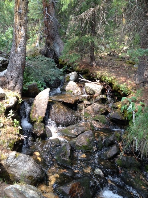
High Mountain Stream
There had been a good deal of rain the evening before our hike, and we did get some sprinkles during the drive up, which made us momentarily reconsider the trip, but decided to push on. We arrived at the trailhead at 9:30, which is very late to start a big hike like this one, but we engaged in the hike, hoping to beat the weather. It sprinkled for much of the ascent, but the skies really never opened up. The really dense fauna, strewn with all different sizes of glacial boulders, in combination with the very low and soggy clouds, make the first 2/3 of the hike feel almost like what I'd imagine a stroll in the Scottish Highlands would. Before the real ascent begins, you meander through very thick bushes on a well marked trail, with nice bridges over the boggier sections. There's also a beautiful stream that cuts through the meadow. The first mile or so would make a great light family outing, and could serve as a fun introduction to Colorado's super high country for kids. But, I digress.

Bouldering to the Summit
Although Bierstadt is considered one of Colorado's "beginner" 14ers, the ascent is quite steep, even grueling at times. As this was my wife's first really big hike, we set a pretty mellow pace, and stopped frequently for water and rest. The initial part of the ascent climbs though dense alpine tundra plant life, and is comprised of pretty manageable switchbacks, but then heads straight up the hill when you begin to make the final transition to the boulder fields at the end of the hike. We made it to the summit at about 1:00, which was about an hour longer than we'd originally assumed, and made us nervous about getting back to meet the bus at 4:30. Luckily, though, the mobile reception was great at the top, and we were able to connect with family members to get them to meet the bus. This ended up being a great move for us later in the hike.

At the summit, we were met by some pretty stingy sleet, and even a bit of hail, and the view was completely consumed in clouds, so our celebration was pretty short lived, and consisted of really just snapping a few pictures. We stopped for a quick lunch at the flat just below the summit, but got moving quickly to get down to flat ground before any big weather might hit. The decent was pretty standard--the classic knee and thigh burner, but we were making pretty good time down the hill. Then, it happened--the skies opened up, and the downpour began. I've honestly never seen this much water fall from the sky, and it continued to come down for two straight hours. We both had good rain coats, but neither of us had packed rain pants; so, needless to say, we were drenched from the waist down, and cold! The trials all turned into little brown rivers at that point, and our decent was slowed to a crawl--in fact, probably doubled. Luckily, we both were able to just laugh through it together. We made it to the car right at about the time we were supposed to meet the bus, and so celebrated the call we'd made earlier. The day was a good lesson in respect for the real power that mother nature really does wield.

We made it, though, and here's our trophy-->

USGS Survey Marker--Mt. Bierstadt

To get there: From 285, Go South through Bailey and Shawnee, and take a right on Co RD 62 (Guanella Pass) in Grant. The trailhead is at the summit of the Pass. You really can't miss it.

Thursday, August 16, 2012

Tanglewood Trail

Tanglewood Creek
In preparation for some bigger hikes, the family and I decided to spend a few hours this week exploring the Tanglewood trail, which is one of the main entrances to the Mt. Evans Wilderness Area from this part of the 285 corridor. We were pleasantly surprised to find this lush, green hike nestled in so close to home. The trail follows Tanglewood Creek for the first three miles or so, and the well fed plants and constant trickle of the stream provided one of the nicest hikes I've been on in some time. You begin the hike well below treeline at a clean bright parking lot, and immediately see some great camping spots right off the beaten path--they're close-in, but feel secluded and private. As you head up the hill, there are tons of little hidden escapes like these, which are perfect for picnicking or a longer overnight stay.

We immediately began noticing the great variety of flora along the path, and topping the list were countless mushroom and toadstool varietals. It was fun getting the kids to pick out all the different types of fungi along the path--we turned it into a fun little naming game, in fact. My favorites were the ones that looked like new red potatoes, but I think my daughter liked the burnt marshmallows the best. For mid-August, the number of flowers still in bloom was quite impressive, and the kids found a ton of wild strawberries and raspberries along the way.
Brightly Colored Toadstool

We did pack a lunch on this trip, but really only planned to be out there for a few hours. It turned into a great 4-hour excursion, and the kids (who are 4 and 9) actually wanted to just keep going all afternoon. This was meant to be a scouting excursion for the upcoming Rosalie Peak trip I have planned with some friends for later this month; but, as serendipity would have it, it turned out to be a great full-day family excursion. The trail ultimately branches off, after treeline, to offer day trips to either the summit of Rosalie or to Roosevelt Lakes, both of which I plan to do this Autumn.

To get there: Heading South on 285 before Bailey, you take a right at the "Loaf'n'Jug" on Co RD 43 (Deer Creek Road). You take 43 all the way to the end (be careful where it intersects with 47--you want to stay to the left), where you'll see a "Fee Area" national forest campground. Pass the campground to the left, and stay on that road until it ends at the parking lot, which is the "Deer Creek Trail Head."

Monday, August 13, 2012

The Falls at Wellington Lake

For our first close-in camping trip of the year, we decided to stay the night at Wellington Lake. It's about 20 minutes outside of Bailey (or less, depending on the washboards), and a very nice wooded drive in. The Lake is first-come-first-serve camping, and they charge per person for day or overnight access (it's all the same price). The lake is nice, although a bit barren looking upon first entering the area; however, the campsites range from lake-view sites (they told me at the front desk that these fill up by Thursday on most summer weekends, so get there early), to some nice large and secluded forest spots. We didn't have our canoe, and so happily opted for the second choice. It was very secluded and quiet--a great spot.

Wellington Lake Falls, from Above
Anyhow, in the morning we woke up at 8-ish and had a little breakfast, and took the advice we'd received from the lady at check-in to do the Waterfall hike. Although not overly strenuous, it's a gorgeous little walk. The trail begins in a very green and flowery meadow, and  quickly is covered in dense wet forest. It's magical feeling, really, almost like a trail in Oregon or like something out of a Grimm story. The hike heads up the hill, and branches off to the longer Castle trail hike, which we didn't take this time, but rather went to the falls and hiked next to them for another half mile or so. There are some gorgeous cave-like structures under some of the falls, and the views of the lake and hills beyond from the boulders above are quite nice.

On the way out, we stopped in at the Cutthroat Cafe for a more proper breakfast. I believe I had the breakfast burrito, which is about my favorite thing after a nice hike. Overall, it was a fantastic day.

To get there: Heading South on 285, take a left immediately at the bottom of Crow Hill (right before you get into Downtown Bailey) and head take the road that follows the Platte out of two for 11 miles.